2.4. GIS and Multi Criteria Techniques in site
selection
Site selection procedures can benefit from the appropriate use
of GIS. Common benefits of GIS include its ability to: (a) capture, store, and
manage spatially referenced data; (b) provide massive amounts of spatially
referenced input data and perform analysis of the data; (c) perform sensitivity
and optimization analysis easily; and (d) communicate model results (Vatalis
& Manoliadis, 2002).
Multi-criteria evaluation (MCE) is used to deal with the
difficulties that decision makers encounter in handling large amounts of
complex information. The principle of the method is to divide the decision
problems into more smaller understandable parts, analyze each part separately,
and then integrate the parts in a logical manner (Malczewski, 1997) . The
integration of GIS and MCE is a powerful tool to solve the landfill site
selection problem because GIS provide efficient manipulation and presentation
of the data and MCE supplies consistent ranking of the potential landfill areas
based on a variety of criteria (Sener, Suzen, & Doyuran, 2006).
(Higgs, 2006) reported the potential of integrating
multi-criteria techniques with GIS in waste facility location and documented
through a review of the existing literature to highlight the opportunities and
challenges facing decision makers at different stages of the waste facility
management process. Moreover, projects with numerous variables are best
approached in GIS using a multi- criteria evaluation (MCE). The MCE is
particularly effective as it allows for designation of suitability values to
portions of the study area so as to determine which sites would be best suited
to meet all criteria.
CHAPTER 3: STUDY AREA AND METHOLOGY
This chapter presents 4 different parts: Study area
description, data and material, methods and techniques and data analysis and
interpretation.
3.1. Study area description
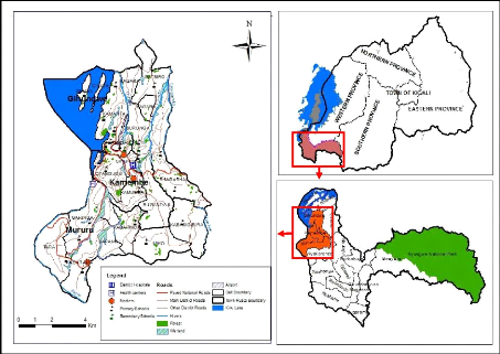
The town of Rusizi is composed of Kamembe, Gihundwe and Mururu
Sectors of Rusizi District. In the west, it shares borders with the Democratic
Republic of Congo, separated by Rusizi River and Lake Kivu. It occupies a
surface area of some 34.94 Km 2 with 70345 populations.
Fig 3- 1: Location map of the study area

14
Source: Author, RNRA/CGIS-NUR
15
3.2. Data and material
Data availability is of prime importance when using GIS.
During this research, the main and specific objectives were achieved after
using primary and secondary data. Field observation and interview with
different District staffs in charge of environment, infrastructure and land
officer land were used as techniques to obtain primary data that were used to
complement spatial data that were used as secondary data. Systematic
exploration of written documents such as books and others was used as
documentation technique.
Spatial data for Rusizi town were collected from Rwanda
Natural Resources Authority (RNRA/Department of Lands and Mapping) through
CGIS-NUR were used to come up with a proposed suitability map for landfill site
selection.
On the other hand, different materials were also used so as to
come up with the expected result. They include:
|
>
|
DEM ( Slope)
|
>
|
Airport
|
|
>
|
Roads network
|
>
|
Market
|
|
>
|
River
|
>
|
Schools ( Primary and Secondary)
|
|
>
|
Lake
|
> Health facilities ( health centers and
|
> Forest District hospitals)
> Wetlands
| 


