3.3. Methods and techniques
The methods and techniques are research tools for data
collection, adapted at the same time for investigation, adapted for analysis
and above all from the point of view, guide the research. The methodology in
this chapter provides evidence for analysis that is utilized to determine the
optimal landfill sites. The technical approach was also employed to produce
suitability maps emphasizing «suitable» geographic areas resulting
from weighted and combined map layers based on established variables.
Methodologies used are normally based on a composite
suitability analysis using map overlays and their extension to include
statistical analysis. In this study, the approach was to utilize models that
combine and integrate maps to determine an optimal landfill siting. There are a
number of integration models in GIS.
Probably the simplest and best-known type of GIS model is
based on Boolean operation. It involves the logical combination of binary maps
resulting from applicable conditional operators. If the criteria and guidelines
are to be established as a set of deterministic rules (Constraints), this
method is a practical and easily applied approach (Dikshit, Padmavathi, &
Das, 2000). The model consists of applying Boolean operators to a set of input
maps. Each of the maps used as a condition can be thought of as a layer of
evidence. The various layers of evidence are combined to support a hypothesis,
or proposition. The output is a binary map, because each location is either
satisfactory or is not (Bonham-Carter, 1994). The following figures show model
builder that were used in this study.
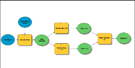
Fig 3-2: Model builder for Factor Map

Source: Author
16
This model builder was used to produce Slope analysis Map (Fig
4-2).
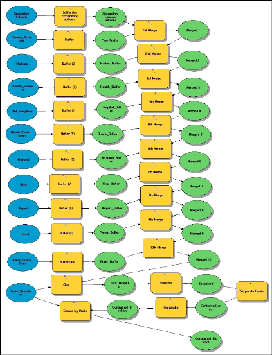
Fig 3-3: Model builder for Constraints Map

Source: Author
17
This model builder was used to produce Constraints and
Permissible Area Map (Fig 4-3).
18
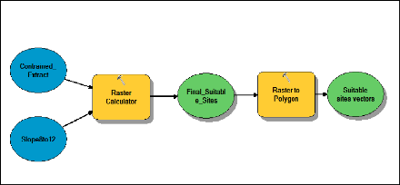
Fig 3-4: Model builder for Final map

Source: Author
This model builder was used to produce Distribution of
Suitable and Potential sites Maps (Fig 4-4 and Fig 4-5).
3.4. Data Analysis and Interpretation
AGIS-based analysis was conducted using ArcGIS software,
Spatial Analyst. Spatial Analyst is a raster or grid based software package
that provides a platform for working with gridded data sets. It was used to
produce suitability maps highlighting «suitable» geographic areas
derived from weighted and combined map layers based on established criteria.
Analyzing spatial layers essentially involves setting the
study area boundary, making slope map, buffer zone maps, find distance from
water body and roads, reclassified maps and suitability maps that are presented
in Chapter 4 of this study.
Raster maps as constraints maps indicating areas, which are
suitable and not suitable for the sitting of a landfill, will be provided. The
non-suitable areas are known as buffers (Kontos, Komilis, & Halavdakis,
2003). These constraints maps include the surface water, towns, rivers, roads,
and land-use. They will also be used as factor maps representing areas that
range from low suitability to high suitability.
CHAPTER 4: WASTE GENERATION AND MANAGEMENT IN RUSIZI:
BOTLENECKS' ANALYSIS AND SUITABLE LANDFILL SITES LOCATION
This chapter presents 4 different parts: Waste generation and
management in Rusizi town, Gaps and challenges in waste management in Rusizi
town, Site selection for landfill in Rusizi town, possibilities for landfill
sites project implementation.
| 


