3.3. Direct methods of mapping forest degradation
Visual interpretation of high resolution data can detect
canopy damage in some cases (Saatchi et al., 2007). Spatial patterns of log
landings (patios for logging trucks and river landings) and identification of
other infrastructure (e.g. roads and rivers used for transportation) has been a
successful approach for identifying degradation (Asner et al., 2005). Likewise
deforestation and forest degradation can be mapped with different techniques,
varying from visual interpretation to advanced image processing algorithms.
13
Among the most classically used techniques Herald et al.,2009;
related some of them Visual interpretation, which can easily detect canopy
damage areas in very high spatial resolution imagery; ii) automate
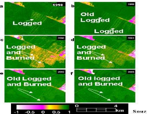
segmentation; iii) spectral mixing analysis for logging disturbances (Asner
et al. 2005, Oliveira et al. 2007) and fire (Souza et
al. 2005); iv) lacunarity indices for canopy structural characterization
(Malhi and Román-Cuesta 2008); vi) Hyperspectral automated canopy
identification (Palace et al. 2008).

Figure 5: Spectral mixing analysis (SMA) as a way to follow the
degradation dynamics of Amazonian
lowland forests using Ikonos sensors
(Souza et al. 2005),
For example Asner et al. (2005) developed automated algorithms
to identify logging activity with Landsat data. Detection of active fires with
thermal data can also indicate presence of subsequent burn scars (Roy et al.,
2005).An effective solution for identifying degraded forests from proximity to
infrastructure has recently been proposed to take advantage of existing
observational approaches given the current limitation in knowledge on the
spatial distribution of biomass (Mollicone et al., 2007).
3.4. Indirect methods of forest degradation mapping
In the study of herald et al. (2009), they tried to explain in
detail this method as The indirect method is useful when degradation intensity
is low and the area to assess is large, when satellite imagery is not easily
accessible, or when the direct approach cannot be applied for whatever other
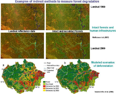
reason. An example of a useful indirect approach is the «intact
forest» approach where the spatial distribution of human infrastructures
(i.e. roads, population centres) are used as proxies, so that the absence of
these are used to identify forest land without anthropogenic disturbance
14
(intact forests) so as to assess the carbon content present in
the disturbed and non-disturbed forest lands (Mollicone et al. 2007;
Potopov et al. 2008 in Herald et al, 2009):
According to this previeous study of herald, Scenario modelling
for forest degradation would be another indirect method which could be applied
to estimate both future and historical forest degradation dynamics..

Figure 6: Estimation of intact and non-intact
forests based on areas of influence (buffers) from human infrastructures
Soares-Filho et al. 2006
3.5. Relevancy of different forest degradation
approach
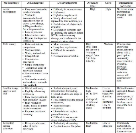
In the study of Achanya and Dangi, 2009 they tried to develop
a relevancy of different forest degradation assessment in Nepal. This method
can also be applied in the tropical region of Africa.
15

Table 3 : Relevance of different forest degradation approach,
source: Acharya and Dangi, 2009
| 


