1.2. Digital image analysis
Digital image analysis in digital remote sensing is analogous
to photo interpretation in analog remote sensing. It is the process by which
the selected imagery is converted/processed into information in the form of a
thematic map. Digital image analysis is performed through a series of steps.
These steps include: (1) image acquisition/selection, (2) pre-processing
including image enhancement, (3) classification, (4) post-processing, and (5)
accuracy assessment.
1.2.1. Image Acquisition/Selection
Selection or acquisition of the appropriate remotely sensed
imagery is foremost determined by the application or objective of the analysis
and the budget. Once these factors are known, the analyst should answer the
questions presented previously. These questions include: what spectral,
spatial, radiometric, temporal resolution and extent are required to accomplish
the objectives of the study within the given budget? Once the answers to these
questions are known, then the analyst can obtain the necessary imagery either
from an archive of existing imagery or request acquisition of a new image from
the appropriate image source.
1.2.2. Pre-processing
Pre-processing is defined as any technique performed on the
image prior to the classification. There are many possible pre-processing
techniques. However, three of the most important techniques include: geometric
registration, radiometric/ atmospheric correction, and numerous forms of image
enhancement.
1.2.3. Classification
Classification of digital data has historically been limited
to spectral information (tone/color). While these methods attempted to build on
the interpretation methods developed in analog remote sensing, the use of the
other elements of photo interpretation beyond just color/tone has been
problematic. In addition, digital image classification has traditionally been
pixel based. A pixel is an arbitrary sample of the ground and
represents the average spectral response for all objects occurring within the
pixel. The earliest classification techniques tended to mimic photo
interpretation and were called supervised classification techniques..
6
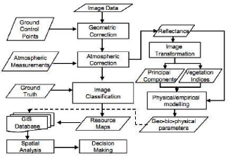
Figure 4 : A schematic diagram of general image processing
procedures, Campbell, 2007
1.2.3.2. Combined Approaches.
Many remote sensing scientists have attempted to combine the
supervised and unsupervised techniques together to take the maximum advantage
of these two techniques while minimizing the disadvantages. Many of these
examples can be found in the literature. A technique by Jensen (2005)
1.2.3.3. Advanced Approaches.
Using supervised or unsupervised classification approaches
only work moderately well. Even the combined approaches only improve our
ability to create accurate thematic maps a little more than using each
technique separately. Therefore, a large amount of effort has been devoted to
developing advanced classification approaches to improve our ability to create
accurate thematic maps from digital remotely sensed imagery. While there are
many advanced approaches, this paper will only mention three: (1)
classification and regression tree (CART) analysis; (2) artificial neural
networks (ANN); and (3) support vector machines (SVM).
|